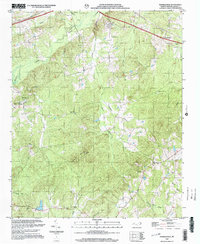
2002 Map of Russellville
USGS Topo · Published 2003About this map
Brown Creek and its many tributaries, including Little Brown Creek and Pinch Gut Creek, carve through this section of Anson County. The landscape is dotted with rural religious centers such as Unity Chapel, West Rocky Ford Ch, and New Grove Ch, serving the dispersed population around Polkton and Russellville. In the north, a State Prison Camp and a Quarry indicate the area's institutional and industrial presence, while the Drive-in Theater near the eastern edge provides a glimpse into the local social life of the era. The terrain rises toward the south at Gordon Mountain and Becky Hill, where the drainage network shifts toward Jones Cr. This survey captures the transition between the rolling Piedmont uplands and the creek bottoms that have historically defined the region's agricultural and settlement patterns.
Find a feature on this map
31 named features on this map. Tap any name to fly to it.
Don’t see what you’re looking for? This feature index may not catch every label — zoom into the map to look around manually.
Map Details
Editions of this 2002 Russellville Map
This is the sole edition of this map. No revisions or reprints were ever made.
Other maps of this area

1941 · Spartanburg
USGS Topo · 1:250,000

1953 · Spartanburg
USGS Topo · 1:250,000

1953 · Charlotte
USGS Topo · 1:250,000

1954 · Charlotte
USGS Topo · 1:250,000

1956 · Ansonville
USGS Topo · 1:24,000

1956 · Wadesboro
USGS Topo · 1:24,000

1960 · Charlotte
USGS Topo · 1:250,000

1960 · Spartanburg
USGS Topo · 1:250,000

1962 · Charlotte
USGS Topo · 1:250,000

1963 · Spartanburg
USGS Topo · 1:250,000