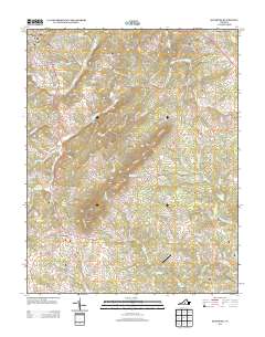
2013 Map of Rustburg
USGS Topo · Published 2013About this map
Rustburg serves as the central hub of this Campbell County landscape, where the Piedmont terrain transitions into significant topographical features like Long Mountain and Wheeler Cliff. The map illustrates a modern rural-suburban hybrid, with established residential clusters at Thomas Terrace and East Brook contrasting with the winding drainages of S Fork Falling River and Tussocky Cr. Aviation history is noted by the presence of Breezy Knoll Airport, while the hydrology of the area is defined by numerous smaller branches like Dutchman Br and Poplar Springs Br feeding into the larger river systems.
Find a feature on this map
148 named features on this map. Tap any name to fly to it.
Don’t see what you’re looking for? This feature index may not catch every label — zoom into the map to look around manually.
Map Details
Editions of this 2013 Rustburg Map
This is the sole edition of this map. No revisions or reprints were ever made.
Other maps of this area

1892 · Lynchburg
USGS Topo · 1:125,000

1892 · Appomattox
USGS Topo · 1:125,000

1944 · Lynchburg
USGS Topo · 1:62,500

1947 · Roanoke
USGS Topo · 1:250,000

1950 · Lynchburg
USGS Topo · 1:62,500

1956 · Brookneal
USGS Topo · 1:62,500

1956 · Gladys
USGS Topo · 1:62,500

1958 · Appomattox
USGS Topo · 1:62,500

1959 · Roanoke
USGS Topo · 1:250,000

1963 · Roanoke
USGS Topo · 1:250,000