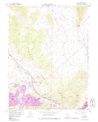
1958 Map of Ruth
USGS Topo · Published 1985About this map
The massive industrial footprint of the Robinson mining district dominates this survey of the Egan Range. Centered around the town of Ruth, the landscape is defined by extensive earthworks including the Liberty Pit and Kimbley Pit, along with sprawling waste sites like the Keystone Dump and Puritan Dump. These operations are connected by the Nevada Northern railroad, which threads through the canyons to serve the high-output copper mines. Eastward, the terrain transitions toward Steptoe Valley, where the settlement of Lane City and the Central Ely Sch mark the fringes of Ely.
Find a feature on this map
59 named features on this map. Tap any name to fly to it.
Don’t see what you’re looking for? This feature index may not catch every label — zoom into the map to look around manually.
Map Details
Editions of this 1958 Ruth Map
Other maps of this area

1952 · Ely
USGS Topo · 1:125,000

1956 · Ely
USGS Topo · 1:250,000

1958 · McGill
USGS Topo · 1:24,000

1958 · Ruth
USGS Topo · 1:24,000

1958 · East Ely
USGS Topo · 1:24,000

1958 · Comins Lake
USGS Topo · 1:24,000

1958 · Ely
USGS Topo · 1:62,500

1958 · McGill
USGS Topo · 1:62,500

1958 · Reipetown
USGS Topo · 1:24,000

1958 · Giroux Wash
USGS Topo · 1:24,000