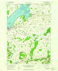
1959 Map of Sackets Harbor
USGS Topo · Published 1961About this map
Sackets Harbor serves as the focal point of this late 1950s survey, positioned where Black River Bay meets Lake Ontario. The village's military legacy is evident through the presence of the Military Cem, a Lookout Tower, and a large Military Reservation. Beyond the harbor, the landscape of Hounsfield and Brownville is defined by a network of historic thoroughfares like Old Military Road and Old State Road, connecting established farming hamlets such as Camps Mills and Stowell Corners. Near the eastern edge, the Watertown Municipal Airport represents the era's infrastructure, while natural features like the marshy Muskalonge Bay and the wooded banks of Stony Creek provide a clear view of the Jefferson County terrain before modern suburban expansion.
Find a feature on this map
66 named features on this map. Tap any name to fly to it.
Don’t see what you’re looking for? This feature index may not catch every label — zoom into the map to look around manually.
Map Details
Editions of this 1959 Sackets Harbor Map
2 editions found
Other maps of this area

1893 · Sackets Harbor
USGS Topo · 1:62,500

1895 · Sacketts Harbor
USGS Topo · 1:62,500

1895 · Watertown
USGS Topo · 1:62,500

1898 · Watertown
USGS Topo · 1:62,500

1900 · Clayton
USGS Topo · 1:62,500

1903 · Clayton
USGS Topo · 1:62,500

1903 · Theresa
USGS Topo · 1:62,500

1908 · Watertown
USGS Topo · 1:62,500

1909 · Watertown
USGS Topo · 1:62,500

1942 · Henderson Bay
USGS Topo · 1:31,680