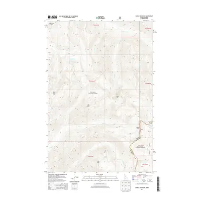
2013 Map of Saddle Mountain
USGS Topo · Published 2013About this map
The Idaho Montana state line bisects this high-elevation wilderness, where the Nez Perce National Forest meets the Bitterroot National Forest. Defined by its drainage basins and sharp ridgelines, the landscape is dotted with remote alpine waters including Battle Lake, Granite Lake, and the Upper Twin Lake near the eastern boundary. Several prominent summits such as Goat Heaven Peaks, Saddle Mtn, and Cove Peak dominate the topography, connected by high crossings like Lost Horse Pass and Wahoo Pass. The intricate stream network, including Wahoo Cr and Granite Cr, demonstrates the complex watershed that characterizes this section of the Northern Rockies. This map provides an essential view of the administrative and natural boundaries during the early twenty-first century, useful for tracing forest management history and the geography of the Bitterroot range.
Find a feature on this map
27 named features on this map. Tap any name to fly to it.
Don’t see what you’re looking for? This feature index may not catch every label — zoom into the map to look around manually.
Map Details
Editions of this 2013 Saddle Mountain Map
This is the sole edition of this map. No revisions or reprints were ever made.
Other maps of this area

1901 · Hamilton
USGS Topo · 1:125,000

1911 · Lolo
USGS Topo · 1:250,000

1913 · Lolo
USGS Topo · 1:250,000

1956 · Hamilton
USGS Topo · 1:250,000

1959 · Hamilton
USGS Topo · 1:250,000

1960 · Hamilton
USGS Topo · 1:250,000

1964 · Hamilton
USGS Topo · 1:250,000

1964 · Tenmile Lake
USGS Topo · 1:24,000
1964 · El Capitan
USGS Topo · 1:24,000

1966 · Twin Butte
USGS Topo · 1:24,000