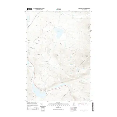
2014 Map of Saddleback Mountain
USGS Topo · Published 2014About this map
Saddleback Mountain and its surrounding peaks dominate this landscape, which is defined by an intricate network of alpine ponds and mountain streams. The Appalachian National Scenic Trail winds across the high ridges, passing notable landmarks like Piazza Rock and overlooking the waters of Eddy Pond and Ethel Pond. To the west, the map captures the edge of Rangeley Lake and the drainage of Nile Brook, while the north is characterized by the headwaters of the S Br Dead River. Local history is anchored by the small settlement of Dallas and family-named sites such as Oakes Peary Cem near Dallas Hill Rd and Brooks Cem along the Sandy River. The geography reveals a balance between high-elevation terrain, including Potato Nubble, and the lower valley systems of Haley Brook and the Sandy River Ponds.
Find a feature on this map
64 named features on this map. Tap any name to fly to it.
Don’t see what you’re looking for? This feature index may not catch every label — zoom into the map to look around manually.
Map Details
Editions of this 2014 Saddleback Mountain Map
This is the sole edition of this map. No revisions or reprints were ever made.
Other maps of this area

1928 · Stratton
USGS Topo · 1:48,000

1929 · Phillips
USGS Topo · 1:48,000

1932 · Phillips
USGS Topo · 1:62,500

1932 · Stratton
USGS Topo · 1:62,500

1932 · Kennebago Lake
USGS Topo · 1:48,000

1933 · Rangeley
USGS Topo · 1:48,000

1935 · Kennebago Lake
USGS Topo · 1:62,500

1936 · Kennebago Lake
USGS Topo · 1:62,500

1939 · Rangeley
USGS Topo · 1:62,500

1949 · Jackman
USGS Topo · 1:250,000
Featured Places
- Dallas Plantation, ME
- Rangeley Plantation, ME
- Madrid Township, ME
- Sandy River Plantation, ME
- Redington Township, ME