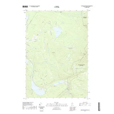
2021 Map of Saddleback Mountain
USGS Topo · Published 2021About this map
Saddleback Mtn dominates the high terrain of Franklin County, where the Appalachian National Scenic Trail traverses the ridgeline past notable landmarks like Piazza Rock. This 2021 survey shows a landscape defined by its complex hydrography, with numerous high-elevation water bodies such as Eddy Pond, Ledge Pond, and Midway Pond feeding into the Sandy River and Cascade Stream systems. The settlement of Dallas and nearby private road networks, including Dallas Hill Rd and Saddleback Mountain Rd, provide access to the recreational and residential developments surrounding Saddleback Lake and Gull Pond.
Find a feature on this map
66 named features on this map. Tap any name to fly to it.
Don’t see what you’re looking for? This feature index may not catch every label — zoom into the map to look around manually.
Map Details
Editions of this 2021 Saddleback Mountain Map
This is the sole edition of this map. No revisions or reprints were ever made.
Other maps of this area

1928 · Stratton
USGS Topo · 1:48,000

1929 · Phillips
USGS Topo · 1:48,000

1932 · Phillips
USGS Topo · 1:62,500

1932 · Stratton
USGS Topo · 1:62,500

1932 · Kennebago Lake
USGS Topo · 1:48,000

1933 · Rangeley
USGS Topo · 1:48,000

1935 · Kennebago Lake
USGS Topo · 1:62,500

1936 · Kennebago Lake
USGS Topo · 1:62,500

1939 · Rangeley
USGS Topo · 1:62,500

1949 · Jackman
USGS Topo · 1:250,000
Featured Places
- Dallas Plantation, ME
- Rangeley Plantation, ME
- Madrid Township, ME
- Sandy River Plantation, ME
- Redington Township, ME