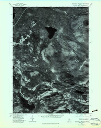
1977 Map of Saddleback Mountain
USGS Topo · Published 1983About this map
Saddleback Mountain dominates this orthophotograph, which provides a high-altitude aerial perspective of the Franklin County landscape as it appeared in late 1977. Unlike traditional line-drawn maps, this image-based survey captures the texture of the Maine woods and the complex drainage systems of the region. The dark, distinct waters of Saddleback Lake sit in the northern half, while Long Pond marks the southwestern reach. The imagery reveals the varied density of the forest and the cleared areas near the town of Dallas. Significant watercourses such as Cascade Stream and Saddleback Stream carve through the elevation, showing the literal path of the mountain's watershed. This specific type of survey is particularly useful for identifying land use patterns and topographical changes that predate modern development in this part of Maine.
Find a feature on this map
7 named features on this map. Tap any name to fly to it.
Don’t see what you’re looking for? This feature index may not catch every label — zoom into the map to look around manually.
Map Details
Editions of this 1977 Saddleback Mountain Map
This is the sole edition of this map. No revisions or reprints were ever made.
Other maps of this area

1928 · Stratton
USGS Topo · 1:48,000

1929 · Phillips
USGS Topo · 1:48,000

1932 · Phillips
USGS Topo · 1:62,500

1932 · Stratton
USGS Topo · 1:62,500

1932 · Kennebago Lake
USGS Topo · 1:48,000

1933 · Rangeley
USGS Topo · 1:48,000

1935 · Kennebago Lake
USGS Topo · 1:62,500

1936 · Kennebago Lake
USGS Topo · 1:62,500

1939 · Rangeley
USGS Topo · 1:62,500

1949 · Jackman
USGS Topo · 1:250,000
Featured Places
- Dallas Plantation, ME
- Rangeley Plantation, ME
- Madrid Township, ME
- Sandy River Plantation, ME
- Redington Township, ME