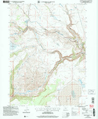
2004 Map of Sage Hen Butte
USGS Topo · Published 2007About this map
Sage Hen Butte dominates the central landscape of this section of the Fremont National Forest, providing a high-elevation anchor for a complex network of seasonal creeks and springs. The map documents the presence of isolated structures and outpost camps typical of the high desert and forest transition, including Schooner Cow Camp, Thompson Cabin, and Limburger Cabin. These sites, along with Wakefield Cabin near the southern margin, suggest the area's legacy of seasonal grazing and timber management. Hydrological features define the terrain, from the Big Reservoir and Crane Lake to the deeply carved path of Deep Creek. This survey reflects the remote character of Lake County, where land use is marked by specialized infrastructure like the Underground Pipeline and the Gaging Station located along the northern reach of Drake Creek.
Find a feature on this map
34 named features on this map. Tap any name to fly to it.
Don’t see what you’re looking for? This feature index may not catch every label — zoom into the map to look around manually.
Map Details
Editions of this 2004 Sage Hen Butte Map
This is the sole edition of this map. No revisions or reprints were ever made.
Other maps of this area

1955 · Klamath Falls
USGS Topo · 1:250,000

1955 · Adel
USGS Topo · 1:250,000

1957 · Adel
USGS Topo · 1:250,000

1958 · Klamath Falls
USGS Topo · 1:250,000

1958 · Adel
USGS Topo · 1:250,000

1962 · Adel
USGS Topo · 1:250,000

1967 · Priday Reservoir
USGS Topo · 1:24,000
1968 · Sage Hen Butte
USGS Topo · 1:24,000

1968 · Crook Peak
USGS Topo · 1:24,000
1968 · Horse Prairie
USGS Topo · 1:24,000