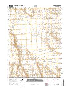
2017 Map of Sage Hen Flats
USGS Topo · Published 2017About this map
Sage Hen Flats defines the high-desert character of this corner of Harney County, where the landscape is shaped by ephemeral water sources and seasonal drainage. The land rises from the flats toward the Sage Hen Hills in the southeast and the steep descent of Sage Hen Canyon to the northwest. Key water management features for livestock or local wildlife are evident, including the Rock Reservoir, Dixon Waterhole, and the secluded Sage Hen Spring. The ephemeral Sage Hen Creek meanders across the territory, crossing the only significant thoroughfare, Ackley Camp Rd. This remote high-plateau environment near the border of Lake County is further distinguished by The Potholes, a geological formation in the northwest that highlights the unique volcanic or erosional history of the Oregon interior.
Find a feature on this map
14 named features on this map. Tap any name to fly to it.
Don’t see what you’re looking for? This feature index may not catch every label — zoom into the map to look around manually.
Map Details
Editions of this 2017 Sage Hen Flats Map
This is the sole edition of this map. No revisions or reprints were ever made.
Other maps of this area

1889 · Long Valley
USGS Topo · 1:250,000

1954 · Vya
USGS Topo · 1:250,000

1955 · Adel
USGS Topo · 1:250,000

1957 · Adel
USGS Topo · 1:250,000

1958 · Vya
USGS Topo · 1:250,000

1958 · Adel
USGS Topo · 1:250,000

1962 · Vya
USGS Topo · 1:250,000

1962 · Adel
USGS Topo · 1:250,000

1966 · Catnip Canyon
USGS Topo · 1:24,000

1966 · Big Spring Butte
USGS Topo · 1:62,500