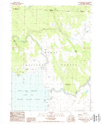
1988 Map of Sagebrush Butte
USGS Topo · Published 1988About this map
Clear Lake National Wildlife Refuge and the Modoc National Forest dominate this borderland where Oregon meets California. The landscape is defined by its complex hydrologic system, centered on the Clear Lake Reservoir and the Willow Valley Reservoir. The Lost River meanders through the northwest, while the southeastern corner is marked by the distinct elevation of Sagebrush Butte. Numerous water sources vital for regional ecology and early land management are recorded, including Plum Spring, Elder Spring, and Rimrock Spring. The inclusion of the Klamath Co Modoc Co boundary line provides essential geographic context for researchers tracing land records across state and county lines in this high-desert environment. In the northeast, Pothole Valley sits near Wilson Rock Creek, showing the varied terrain of this protected wilderness area.
Find a feature on this map
22 named features on this map. Tap any name to fly to it.
Don’t see what you’re looking for? This feature index may not catch every label — zoom into the map to look around manually.
Map Details
Editions of this 1988 Sagebrush Butte Map
This is the sole edition of this map. No revisions or reprints were ever made.
Other maps of this area

1886 · Alturas
USGS Topo · 1:250,000

1886 · Modoc Lava Bed
USGS Topo · 1:250,000

1889 · Klamath
USGS Topo · 1:250,000

1892 · Modoc Lava-Bed
USGS Topo · 1:250,000

1892 · Alturas
USGS Topo · 1:250,000

1894 · Klamath
USGS Topo · 1:250,000

1951 · Clear Lake Reservoir
USGS Topo · 1:62,500

1954 · Alturas
USGS Topo · 1:250,000

1955 · Klamath Falls
USGS Topo · 1:250,000

1958 · Alturas
USGS Topo · 1:250,000