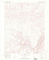
1967 Map of Saguache Park
USGS Topo · Published 1969About this map
The Continental Divide defines the crest of this high mountain landscape, where the Cochetopa Hills meet the expansive meadowlands of Saguache Park. This 1967 field-checked survey highlights the transition between the Gunnison National Forest to the north and the Rio Grande National Forest to the south. Central to the map is the Stone Cellar Guard Station, a key administrative site situated near the confluence of the Middle Fork and Saguache Creek. The terrain is marked by numerous watercourses such as Little North Fork Rio Grande and Miners Creek, along with prominent landmarks like Chimney Rock. A network of Jeep Trails and Pack Trails indicates a remote region primarily utilized for forest management and backcountry access, with labels like Mexican Joe Gulch preserving local family or prospector names.
Find a feature on this map
25 named features on this map. Tap any name to fly to it.
Don’t see what you’re looking for? This feature index may not catch every label — zoom into the map to look around manually.
Map Details
Editions of this 1967 Saguache Park Map
3 editions found
Other maps of this area

1914 · Creede
USGS Topo · 1:125,000

1916 · Creede
USGS Topo · 1:125,000

1945 · Durango
USGS Topo · 1:250,000

1953 · Durango
USGS Topo · 1:250,000

1954 · Durango
USGS Topo · 1:250,000

1956 · Montrose
USGS Topo · 1:250,000

1959 · Montrose
USGS Topo · 1:250,000

1959 · Creede
USGS Topo · 1:62,500

1960 · Montrose
USGS Topo · 1:250,000

1961 · Durango
USGS Topo · 1:250,000