1967 Map of Saguache
USGS Topo · Published 1980About this map
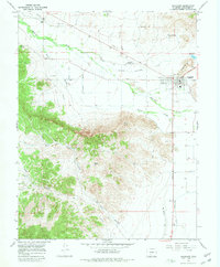
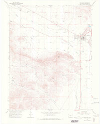
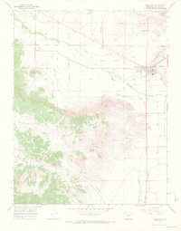
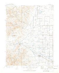
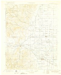
Saguache serves as the focal point of this San Luis Valley survey, situated where the high desert floor meets the rising foothills. The town's layout reflects a typical Western grid, bordered by essential resources like the Saguache Reservoir and the Saguache Municipal Airport. Local history is anchored by the Hillside Cem and Campo Santo Cem, while the industrial past is marked by a Smelter located near Findley Gulch. Water management, critical to this arid landscape, is extensively documented through the Lawrence Ditch, Werner Arroyo, and the Rio Grande Canal. Beyond the settlement, the terrain transitions into the rugged drainage of Tracy Canyon and North Tracy Canyon, punctuated by landmarks such as Devils Knob and Flagpole Hill. The presence of Onion Spring and various prospect sites suggests a history of both ranching and mineral exploration in the surrounding peaks.
Find a feature on this map
21 named features on this map. Tap any name to fly to it.
Don’t see what you’re looking for? This feature index may not catch every label — zoom into the map to look around manually.
Map Details
Editions of this 1967 Saguache Map
3 editions found
Other maps of this area
1915 · Del Norte
USGS Topo · 1:125,000
1917 · Del Norte
USGS Topo · 1:125,000

1945 · Durango
USGS Topo · 1:250,000

1953 · Durango
USGS Topo · 1:250,000

1954 · Durango
USGS Topo · 1:250,000

1956 · Montrose
USGS Topo · 1:250,000

1959 · Montrose
USGS Topo · 1:250,000

1960 · Montrose
USGS Topo · 1:250,000

1961 · Durango
USGS Topo · 1:250,000

1963 · Durango
USGS Topo · 1:250,000