1967 Map of Saguache
USGS Topo · Published 1971About this map
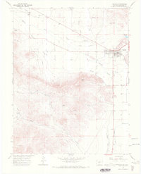
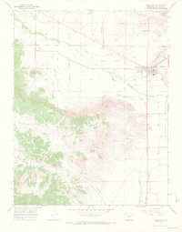
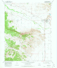
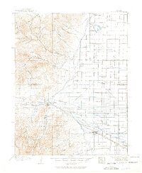
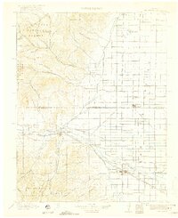
Saguache serves as the focal point for this 1967 survey, where the San Luis Valley meets the rising foothills. The town's layout is meticulously detailed, showing the concentration of civic life near Hillside Cem and the Saguache Municipal Airport. The surrounding landscape is defined by an intricate network of water management, including the Lawrence Ditch, Saguache Reservoir, and the Rio Grande Canal, reflecting the region's agricultural reliance on coordinated irrigation. Beyond the irrigated flats, the terrain rises sharply toward landmarks like Flagpole Hill and Devils Knob. High-desert features such as Onion Spring and various Prospects dot the southern canyons, while the northern edge near the Smelter points to the area's industrial history. Genealogists will find the location of both Hillside Cem and the Campo Santo Cem particularly valuable for tracing local family history.
Find a feature on this map
28 named features on this map. Tap any name to fly to it.
Don’t see what you’re looking for? This feature index may not catch every label — zoom into the map to look around manually.
Map Details
Editions of this 1967 Saguache Map
3 editions found
Other maps of this area
1915 · Del Norte
USGS Topo · 1:125,000
1917 · Del Norte
USGS Topo · 1:125,000

1945 · Durango
USGS Topo · 1:250,000

1953 · Durango
USGS Topo · 1:250,000

1954 · Durango
USGS Topo · 1:250,000

1956 · Montrose
USGS Topo · 1:250,000

1959 · Montrose
USGS Topo · 1:250,000

1960 · Montrose
USGS Topo · 1:250,000

1961 · Durango
USGS Topo · 1:250,000

1963 · Durango
USGS Topo · 1:250,000