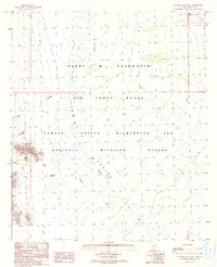
1990 Map of Saguaro Gap Well
USGS Topo · Published 1990About this map
Cabeza Prieta Wilderness and National Wildlife Refuge dominates this desert landscape, where the shifting sands of Growler Valley meet the rising peaks of the Granite Mountains. This 1990 map reflects a region defined by large-scale federal conservation and military use, notably the southern portion of the Barry M Goldwater Air Force Range. Human activity is centered on vital water sources like the Saguaro Gap Well, an essential marker in this arid environment. The map details the complex drainage patterns of Growler Wash as it cuts through the valley floor, alongside the narrow passage of Saguaro Gap itself. This provisional survey provides a precise view of the topography and restricted zones established during the late 20th century in Pima County.
Find a feature on this map
10 named features on this map. Tap any name to fly to it.
Don’t see what you’re looking for? This feature index may not catch every label — zoom into the map to look around manually.
Map Details
Editions of this 1990 Saguaro Gap Well Map
This is the sole edition of this map. No revisions or reprints were ever made.
Other maps of this area

1953 · Ajo
USGS Topo · 1:250,000

1957 · Ajo
USGS Topo · 1:250,000

1958 · Ajo
USGS Topo · 1:250,000

1962 · Ajo
USGS Topo · 1:250,000

1963 · Ajo
USGS Topo · 1:250,000

1964 · Growler Peak
USGS Topo · 1:62,500
1964 · Agua Dulce Mts
USGS Topo · 1:62,500

1965 · O'Neill Hills
USGS Topo · 1:62,500

1965 · Granite Mountains
USGS Topo · 1:62,500

1967 · Ajo
USGS Topo · 1:250,000