1981 Map of Saint Augustine
USGS Topo · Published 1982About this map
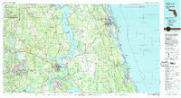
The St Johns River anchors this regional study, winding northward through a landscape of wetlands, state parks, and historic settlements as it appeared in the early 1980s. Along the Atlantic coast, the ancient city of St Augustine and its neighboring Anastasia Island show a developed coastline featuring Anastasia State Park and St Augustine Beach. Inland, the map documents the critical water and transport infrastructure of Northeast Florida, from the Cross Florida Barge Canal and Rodman Reservoir in the south to the military grounds of Camp Blanding in the northwest. The rail-and-river economy is visible through the Florida East Coast Railway and Seaboard Coast Line tracks that connect river towns like Palatka and Green Cove Springs to the coast. This era records the region before significant modern suburban expansion, preserving the layout of older communities such as Penney Farms and Bostwick.
Find a feature on this map
132 named features on this map. Tap any name to fly to it.
Don’t see what you’re looking for? This feature index may not catch every label — zoom into the map to look around manually.
Map Details
Editions of this 1981 Saint Augustine Map
2 editions found

Other maps of this area

1893 · Citra
USGS Topo · 1:62,500

1895 · Citra
USGS Topo · 1:62,500

1912 · Palatka
USGS Topo · 1:48,000

1915 · Palatka
USGS Topo · 1:62,500

1915 · Interlachen
USGS Topo · 1:48,000

1916 · Interlachen
USGS Topo · 1:62,500

1917 · Orange Park
USGS Topo · 1:62,500

1918 · Middleburg
USGS Topo · 1:62,500

1918 · Lawtey
USGS Topo · 1:62,500

1918 · Orange Park
USGS Topo · 1:62,500