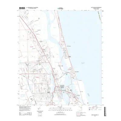
2015 Map of Saint Augustine
USGS Topo · Published 2015About this map
Castillo de San Marcos National Monument stands as the historic centerpiece of St. Augustine, anchoring a landscape where the San Sebastian River and Matanzas River meet the Atlantic. This 2015 survey details the dense coastal development and legacy sites that define Florida's oldest city. Genealogists and local historians can trace burial grounds such as Evergreen Cem, Woodlawn Cem, and Mount Pleasant Cem. The map illustrates the complex waterway system, including the Intracoastal Waterway and the Saint Augustine Inlet, which separate the mainland from Anastasia Island and Conch Island. Significant infrastructure like the Northeast Florida Regional Airport and the Florida East Coast Railway at Moultrie Junction show the modern connectivity of this historic corridor, while smaller communities like Araquey and Casa Cola provide a view into the residential expansion north of the city center.
Find a feature on this map
218 named features on this map. Tap any name to fly to it.
Don’t see what you’re looking for? This feature index may not catch every label — zoom into the map to look around manually.
Map Details
Editions of this 2015 Saint Augustine Map
This is the sole edition of this map. No revisions or reprints were ever made.
Other maps of this area

1918 · Palm Valley
USGS Topo · 1:62,500

1937 · Bakersville
USGS Topo · 1:24,000

1937 · Elkton
USGS Topo · 1:24,000

1937 · Crescent Beach
USGS Topo · 1:24,000

1937 · St. Augustine
USGS Topo · 1:24,000

1943 · St. Augustine
USGS Topo · 1:62,500

1948 · Jacksonville
USGS Topo · 1:250,000
1952 · South Ponte Vedra Beach
USGS Topo · 1:24,000
1952 · Durbin
USGS Topo · 1:24,000

1954 · Daytona Beach
USGS Topo · 1:250,000