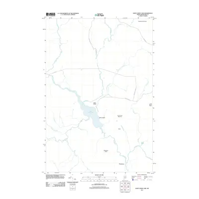
2011 Map of Saint Croix Lake
USGS Topo · Published 2011About this map
Saint Croix Lake serves as the central anchor for this remote section of Aroostook County, where the settlement of Howe Brook sits at the northern end of the water. The landscape is defined by its extensive drainage network, including Saint Croix Stream and Smith Brook, alongside notable elevations such as Howe Brook Mountain and Nighthawk Mountain. The presence of Weeksboro and Little Canada suggests small pockets of habitation tied to the historic logging and rail infrastructure of Northern Maine. Local roads and transit routes like Harvey Siding Rd and the Mud Lake Tote Rd provide access through the timberlands, connecting these isolated outposts with the surrounding ridges. Genealogists and historians can trace the traditional pathways and seasonal settlements that characterized this interior wilderness in the early 21st century.
Find a feature on this map
30 named features on this map. Tap any name to fly to it.
Don’t see what you’re looking for? This feature index may not catch every label — zoom into the map to look around manually.
Map Details
Editions of this 2011 Saint Croix Lake Map
This is the sole edition of this map. No revisions or reprints were ever made.
Other maps of this area

1935 · Howe Brook
USGS Topo · 1:48,000

1937 · Smyrna Mills
USGS Topo · 1:62,500

1939 · Howe Brook
USGS Topo · 1:62,500

1940 · Island Falls
USGS Topo · 1:62,500

1940 · Oxbow
USGS Topo · 1:62,500

1942 · Island Falls
USGS Topo · 1:62,500

1942 · Oxbow
USGS Topo · 1:62,500

1954 · Howe Brook
USGS Topo · 1:62,500

1954 · Presque Isle
USGS Topo · 1:250,000

1955 · Smyrna Mills
USGS Topo · 1:62,500
Featured Places
- Howe Brook, Saint Croix Township
- Weeksboro, Dudley Township
- Dudley Township, ME
- Webbertown Township, ME
- Saint Croix Township, ME