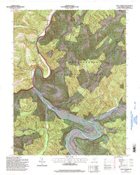
1995 Map of Saint George
USGS Topo · Published 1998About this map
The Cheat River carves a dramatic path through the heart of Tucker County, creating the prominent Horseshoe Bend near the settlement of Saint George. This 1990s record, based on topographical data compiled in the mid-century, reveals a landscape defined by isolated mountain ridges and deeply cut stream valleys within the Monongahela National Forest. Small communities and family landmarks are scattered throughout the Saint George District and Licking District, often centered around country churches such as Macedonia Ch and Limestone Ch.
Find a feature on this map
44 named features on this map. Tap any name to fly to it.
Don’t see what you’re looking for? This feature index may not catch every label — zoom into the map to look around manually.
Map Details
Editions of this 1995 Saint George Map
This is the sole edition of this map. No revisions or reprints were ever made.
Other maps of this area

1886 · St. George
USGS Topo · 1:125,000

1891 · St. George
USGS Topo · 1:125,000

1907 · Thornton
USGS Topo · 1:62,500

1907 · Kingwood
USGS Topo · 1:62,500

1907 · Belington
USGS Topo · 1:62,500

1908 · Parsons
USGS Topo · 1:62,500

1925 · Kingwood
USGS Topo · 1:62,500

1926 · Thornton
USGS Topo · 1:62,500

1926 · Parsons
USGS Topo · 1:62,500

1927 · Belington
USGS Topo · 1:62,500