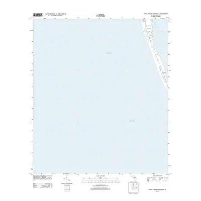
2012 Map of Saint Joseph Peninsula
USGS Topo · Published 2012About this map
The Saint Joseph Peninsula forms a narrow, protective barrier between the open Gulf of Mexico and the calm waters of Saint Josephs Bay in this 2012 coastal survey. The map details the thin strip of land along Cape San Blas Rd, where residential developments like Seacliff Dr, Blue Heron Dr, and Spinnaker Way have been established. This area represents a sensitive coastal landscape where human infrastructure meets the shifting sands of the Gulf Coast. Further south, the map identifies Lee Ward and Haven Rd as they approach the interior side of the bay, while the small landform of Pig Island sits just offshore in the bay's shallow waters. The layout illustrates the concentration of local access roads and vacation properties that define this modern era of the Florida Panhandle's shoreline.
Find a feature on this map
10 named features on this map. Tap any name to fly to it.
Don’t see what you’re looking for? This feature index may not catch every label — zoom into the map to look around manually.
Map Details
Editions of this 2012 Saint Joseph Peninsula Map
This is the sole edition of this map. No revisions or reprints were ever made.
Other maps of this area

1943 · St Joseph Spit
USGS Topo · 1:31,680

1943 · Port St. Joe
USGS Topo · 1:31,680

1943 · Cape San Blas
USGS Topo · 1:31,680

1945 · St Joseph Point
USGS Topo · 1:31,680

1949 · Apalachicola
USGS Topo · 1:250,000

1957 · Apalachicola
USGS Topo · 1:250,000

1959 · Apalachicola
USGS Topo · 1:250,000
1960 · Apalachicola
USGS Topo · 1:250,000
1967 · Apalachicola
USGS Topo · 1:250,000
1978 · Port Saint Joe
USGS Topo · 1:100,000