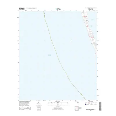
2015 Map of Saint Joseph Peninsula
USGS Topo · Published 2015About this map
Saint Joseph Peninsula stretches between the calm waters of Saint Joseph Bay and the open Gulf of Mexico on this Florida coastal map. The landscape is defined by its narrow maritime geography, where a handful of residential roads such as Seacliff Dr and Haven Rd mark the limited human footprint on the northern reaches of the spit. The map highlights the intricate shoreline of the bay side, including Pig Island and the secluded Pig Bayou, which suggest a fragile environment of marshes and inlets. The presence of the Gulf County boundary line traversing the open water reflects the importance of maritime jurisdictional limits in this coastal region.
Find a feature on this map
15 named features on this map. Tap any name to fly to it.
Don’t see what you’re looking for? This feature index may not catch every label — zoom into the map to look around manually.
Map Details
Editions of this 2015 Saint Joseph Peninsula Map
This is the sole edition of this map. No revisions or reprints were ever made.
Other maps of this area

1943 · St Joseph Spit
USGS Topo · 1:31,680

1943 · Port St. Joe
USGS Topo · 1:31,680

1943 · Cape San Blas
USGS Topo · 1:31,680

1945 · St Joseph Point
USGS Topo · 1:31,680

1949 · Apalachicola
USGS Topo · 1:250,000

1957 · Apalachicola
USGS Topo · 1:250,000

1959 · Apalachicola
USGS Topo · 1:250,000
1960 · Apalachicola
USGS Topo · 1:250,000
1967 · Apalachicola
USGS Topo · 1:250,000
1978 · Port Saint Joe
USGS Topo · 1:100,000