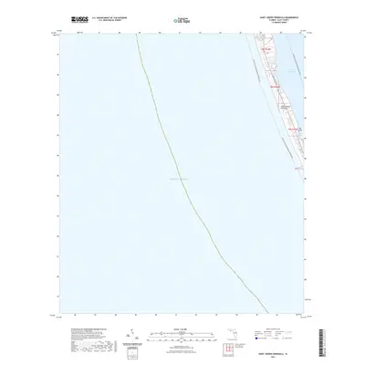
2021 Map of Saint Joseph Peninsula
USGS Topo · Published 2021About this map
Saint Joseph Peninsula forms a narrow barrier between the open waters of the Gulf of Mexico and the sheltered Saint Joseph Bay. This coastal environment is defined by its slender profile, where Cape San Blas Rd serves as the primary corridor running the length of the landform. The geography here is marked by tidal features and small interior waterways like Pig Bayou and the adjacent Pig Island.
Find a feature on this map
10 named features on this map. Tap any name to fly to it.
Don’t see what you’re looking for? This feature index may not catch every label — zoom into the map to look around manually.
Map Details
Editions of this 2021 Saint Joseph Peninsula Map
This is the sole edition of this map. No revisions or reprints were ever made.
Other maps of this area

1943 · St Joseph Spit
USGS Topo · 1:31,680

1943 · Port St. Joe
USGS Topo · 1:31,680

1943 · Cape San Blas
USGS Topo · 1:31,680

1945 · St Joseph Point
USGS Topo · 1:31,680

1949 · Apalachicola
USGS Topo · 1:250,000

1957 · Apalachicola
USGS Topo · 1:250,000

1959 · Apalachicola
USGS Topo · 1:250,000
1960 · Apalachicola
USGS Topo · 1:250,000
1967 · Apalachicola
USGS Topo · 1:250,000
1978 · Port Saint Joe
USGS Topo · 1:100,000