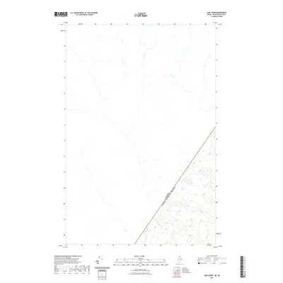
2021 Map of Saint Omer
USGS Topo · Published 2021About this map
The international border between the Canada United States of America defines the landscape of this remote Maine borderland in northern Aroostook County. This survey, based on data collected between 2003 and 2019, shows the precise demarcation of the boundary line as it cuts through the high-elevation terrain of the North Maine Woods. While the map is dominated by the hydrology of unnamed streams and the dense contour intervals of the surrounding ridges, it primarily serves as a modern spatial record of the geopolitical boundary. The stark division between the nations is the primary feature of this quadrangle, illustrating the diagonal path of the border as it separates American soil from Quebec.
Find a feature on this map
1 named feature on this map. Tap any name to fly to it.
Don’t see what you’re looking for? This feature index may not catch every label — zoom into the map to look around manually.
Map Details
Editions of this 2021 Saint Omer Map
This is the sole edition of this map. No revisions or reprints were ever made.
Other maps of this area

1954 · Presque Isle
USGS Topo · 1:250,000

1955 · Little East Lake
USGS Topo · 1:62,500

1955 · Depot Lake
USGS Topo · 1:62,500

1955 · Seven Islands
USGS Topo · 1:62,500

1958 · Presque Isle
USGS Topo · 1:250,000

1960 · Presque Isle
USGS Topo · 1:250,000

1962 · Edmundston
USGS Topo · 1:250,000

1976 · East Lake
USGS Topo · 1:24,000

1976 · East Lake SE
USGS Topo · 1:24,000
1976 · St. Pamphile
USGS Topo · 1:24,000