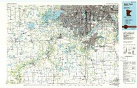
1985 Map of Saint Paul
USGS Topo · Published 1985About this map
The confluence of the Mississippi River and Minnesota River serves as the focal point for this mid-1980s survey, anchoring the urban development of Minneapolis and Saint Paul. This planimetric study details the sprawling infrastructure of the Twin Cities, highlighting the significance of the Fort Snelling Military Reservation and the adjacent Minneapolis-St Paul International Airport. Beyond the urban core, the map traces the preservation of the river corridor through the Minnesota Valley National Wildlife Refuge, which includes specialized areas like the Louisville Swamp Unit.
Find a feature on this map
376 named features on this map. Tap any name to fly to it.
Don’t see what you’re looking for? This feature index may not catch every label — zoom into the map to look around manually.
Map Details
Editions of this 1985 Saint Paul Map
2 editions found
Other maps of this area

1896 · Minneapolis
USGS Topo · 1:62,500

1896 · St. Paul
USGS Topo · 1:62,500

1901 · Minneapolis
USGS Topo · 1:62,500

1902 · White Bear
USGS Topo · 1:62,500

1902 · Anoka
USGS Topo · 1:62,500

1905 · Minnetonka
USGS Topo · 1:62,500

1907 · Minnetonka
USGS Topo · 1:62,500

1909 · Rockford
USGS Topo · 1:62,500

1946 · Hudson
USGS Topo · 1:62,500

1948 · Stillwater
USGS Topo · 1:62,500