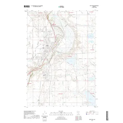
2019 Map of Saint Peter
USGS Topo · Published 2019About this map
The St. Peter townsite and the neighboring village of Kasota are the focal points of this Nicollet and Le Sueur County landscape. The sprawling campus of Gustavus Adolphus College overlooks the valley, while the Minnesota River snakes between the two communities, defining the county line. The map is particularly rich for genealogical research, documenting several burial sites including the Pettis Klaseus Family Cem, Green Lawn Cem, and Welsh Cem. Significant local geography is recorded through water bodies such as Lake Washington, Lake Emily, and the State Hospital Pond. The extensive local road network, including the historic Dodd Rd and Dodd Ave, connects the residential streets of St. Peter to the surrounding agricultural and marshy terrain of the river valley.
Find a feature on this map
73 named features on this map. Tap any name to fly to it.
Don’t see what you’re looking for? This feature index may not catch every label — zoom into the map to look around manually.
Map Details
Editions of this 2019 Saint Peter Map
This is the sole edition of this map. No revisions or reprints were ever made.
Other maps of this area

1950 · Mankato East
USGS Topo · 1:62,500

1951 · Mankato East
USGS Topo · 1:62,500

1951 · Mankato West
USGS Topo · 1:62,500

1953 · Saint Paul
USGS Topo · 1:250,000

1953 · New Ulm
USGS Topo · 1:250,000

1957 · New Ulm
USGS Topo · 1:250,000

1958 · New Ulm
USGS Topo · 1:250,000

1959 · Saint Paul
USGS Topo · 1:250,000

1965 · Cleveland
USGS Topo · 1:24,000

1965 · Norseland
USGS Topo · 1:24,000
Featured Places
- Saint Peter, St. Peter
- Kasota, MN
- Ottawa Township, MN
- Mar Wey Mobile Home Park, St. Peter
- Summit Mobile Home Park, St. Peter