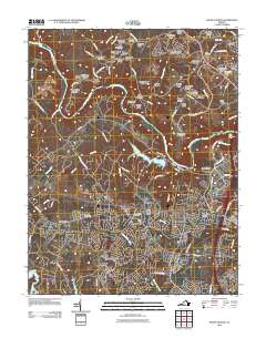
2011 Map of Salem Church
USGS Topo · Published 2011About this map
Salem Church sits near the heart of this landscape, marking a region where modern suburban growth meets deep-seated Virginian history. The terrain is defined by the convergence of the Rapidan River and the Rappahannock River, with the Motts Run Reservoir and its surrounding hills providing a significant hydrological anchor. The 2011 residential patterns are evident in the proliferation of named estates and developments like Stafford Lakes Village and Kimberly Estates, yet the persistence of traditional landmarks like the Berea Plantation and Mansfield Manor speaks to the area's older agricultural roots. Genealogists and local historians can locate several burial grounds, including the Tabernacle Cemetery and Mount Hope Cemetery, which serve as vital physical records of the families who settled this part of Spotsylvania County. The map also traces the winding paths of numerous runs and creeks, such as Massaponax Creek and Hazel Run, that shaped the original settlement corridors.
Find a feature on this map
106 named features on this map. Tap any name to fly to it.
Don’t see what you’re looking for? This feature index may not catch every label — zoom into the map to look around manually.
Map Details
Editions of this 2011 Salem Church Map
This is the sole edition of this map. No revisions or reprints were ever made.
Other maps of this area

1887 · Spottsylvania
USGS Topo · 1:125,000

1889 · Fredericksburg
USGS Topo · 1:125,000

1892 · Fredericksburg
USGS Topo · 1:125,000

1892 · Spottsylvania
USGS Topo · 1:125,000

1894 · Fredericksburg
USGS Topo · 1:125,000

1926 · Stafford
USGS Topo · 1:62,500

1931 · Stafford
USGS Topo · 1:62,500

1942 · Guinea
USGS Topo · 1:31,680

1942 · Spotsylania
USGS Topo · 1:31,680

1942 · Brokenburg
USGS Topo · 1:31,680