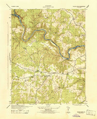
1944 Map of Salem Church
USGS Topo · Published 1944About this map
The winding Rappahannock River and Rapidan River define this wartime landscape, carving deep contours through the borderlands of Spotsylvania County, Stafford County, and Culpeper County. The map reveals a mid-century rural network concentrated around road junctions and community institutions, particularly visible at Five Mile Fork and the area near Chancellor. Educational and religious life are anchored by several named sites, including Chancellor School, Diggs School, and the namesake Salem Church.
Find a feature on this map
28 named features on this map. Tap any name to fly to it.
Don’t see what you’re looking for? This feature index may not catch every label — zoom into the map to look around manually.
Map Details
Editions of this 1944 Salem Church Map
This is the sole edition of this map. No revisions or reprints were ever made.
Other maps of this area

1887 · Spottsylvania
USGS Topo · 1:125,000

1889 · Fredericksburg
USGS Topo · 1:125,000

1892 · Fredericksburg
USGS Topo · 1:125,000

1892 · Spottsylvania
USGS Topo · 1:125,000

1894 · Fredericksburg
USGS Topo · 1:125,000

1926 · Stafford
USGS Topo · 1:62,500

1931 · Stafford
USGS Topo · 1:62,500

1942 · Guinea
USGS Topo · 1:31,680

1942 · Spotsylania
USGS Topo · 1:31,680

1942 · Brokenburg
USGS Topo · 1:31,680