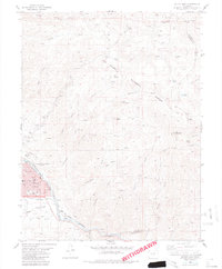
1983 Map of Salida East
USGS Topo · Published 1983About this map
The Arkansas River defines the western edge of this landscape, carving a valley between the town of Salida and the high terrain of the San Isabel National Forest. This 1983 edition shows the community's established layout, with the Courthouse and hospital situated near the riverbanks. The town’s industrial and transportation history is anchored by the Denver and Rio Grande Western RR, which follows the river’s path, supported by local infrastructure like the Gaging Station.
Find a feature on this map
54 named features on this map. Tap any name to fly to it.
Don’t see what you’re looking for? This feature index may not catch every label — zoom into the map to look around manually.
Map Details
Editions of this 1983 Salida East Map
3 editions found
Other maps of this area

1954 · Pueblo
USGS Topo · 1:250,000

1956 · Cameron Mountain
USGS Topo · 1:62,500

1956 · Poncha Springs
USGS Topo · 1:62,500

1956 · Montrose
USGS Topo · 1:250,000

1957 · Pueblo
USGS Topo · 1:250,000

1958 · Pueblo
USGS Topo · 1:250,000

1959 · Montrose
USGS Topo · 1:250,000

1959 · Bonanza
USGS Topo · 1:62,500

1959 · Howard
USGS Topo · 1:62,500

1960 · Montrose
USGS Topo · 1:250,000