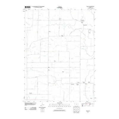
2010 Map of Salina
USGS Topo · Published 2010About this map
Germanville and Salina anchor this agrarian landscape in Jefferson County, where a dense network of local cemeteries reveals the heritage of nineteenth-century European settlement. The map documents an area defined by its small rural crossroads and the winding tributaries of Walnut Creek, including Rocky Branch and Turkey Creek. For genealogists, the sheer concentration of burial sites is remarkable, ranging from the Polishville Cemetery in the north to the cluster of Swedish heritage sites in the south, such as the New Sweden Baptist Cemetery and New Sweden Lutheran Cemetery. The transition from the established community at Four Corners to the rail-adjacent settlement of Beckwith illustrates the historical importance of local road and stream networks. Between the drainage basins of Brush Creek and Wolf Creek, this survey provides a precise layout of the county's section-line roads and the family-named landmarks that have persisted through generations of Iowa farming.
Find a feature on this map
63 named features on this map. Tap any name to fly to it.
Don’t see what you’re looking for? This feature index may not catch every label — zoom into the map to look around manually.
Map Details
Editions of this 2010 Salina Map
This is the sole edition of this map. No revisions or reprints were ever made.
Other maps of this area

1958 · Burlington
USGS Topo · 1:250,000

1958 · Davenport
USGS Topo · 1:250,000

1961 · Burlington
USGS Topo · 1:250,000

1961 · Davenport
USGS Topo · 1:250,000

1962 · Davenport
USGS Topo · 1:250,000

1963 · Burlington
USGS Topo · 1:250,000
1980 · Fairfield North
USGS Topo · 1:24,000
1980 · Richland
USGS Topo · 1:24,000

1980 · Brighton
USGS Topo · 1:24,000
1980 · Fairfield South
USGS Topo · 1:24,000