
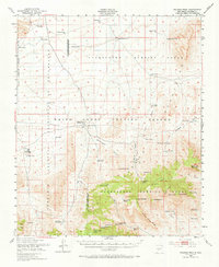
1948 Map of Salinas Peak
USGS Topo · Published 1955About this map
The Alamogordo Bombing Range and the White Sands Proving Ground dominate this high-desert landscape, reflecting a post-war era of military expansion and aerospace research. The terrain is defined by dramatic elevations and isolated ranching operations that existed alongside military testing sites. Landmarks like Salinas Peak and Silver Top Mountain tower over a network of canyons, including Cottonwood Canyon and Jance Canyon, while the Gyp Hills provide a distinct geological contrast to the south.
Find a feature on this map
67 named features on this map. Tap any name to fly to it.
Don’t see what you’re looking for? This feature index may not catch every label — zoom into the map to look around manually.
Map Details
Editions of this 1948 Salinas Peak Map
2 editions found
Other maps of this area

1916 · Salinas Peak
USGS Topo · 1:125,000

1916 · Tularosa
USGS Topo · 1:125,000

1918 · Oscura Peak
USGS Topo · 1:125,000

1947 · Capitol Peak
USGS Topo · 1:62,500

1948 · Sowell
USGS Topo · 1:62,500

1948 · Granjean Well
USGS Topo · 1:62,500

1948 · Val Verde
USGS Topo · 1:62,500

1948 · Malpais Well
USGS Topo · 1:62,500

1948 · Black Top Mountain
USGS Topo · 1:62,500

1948 · Mockingbird Gap
USGS Topo · 1:62,500