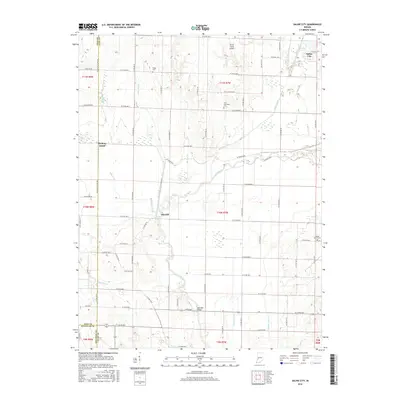
2016 Map of Saline City
USGS Topo · Published 2016About this map
Saline City sits at the junction of Birch Creek and Crooked Cr in this contemporary record of Clay County's water-rich landscape. The terrain is defined by its drainage patterns, notably the Eel River which meanders through the central and southern portions of the quadrangle. Significant wetland and overflow features like Little Slough, Big Slough, and Splunge Creek illustrate the low-lying character of the land, once home to substantial marshlands. Evidence of the region's agricultural and rural history remains through family-named landmarks such as Stagg Cem, Zion Gummere Cem, and Maple Grove Cem. The map preserves the location of Old Hill and the river crossing at Neal Mill Bridge, while also noting more modern developments like the Turner Farms Airport. For those tracing the evolution of local infrastructure, the alignment of W Towpath Rd suggests the historical path of bygone transportation routes along the river corridor.
Find a feature on this map
75 named features on this map. Tap any name to fly to it.
Don’t see what you’re looking for? This feature index may not catch every label — zoom into the map to look around manually.
Map Details
Editions of this 2016 Saline City Map
This is the sole edition of this map. No revisions or reprints were ever made.
Other maps of this area

1908 · Clay City
USGS Topo · 1:48,000

1910 · Clay City
USGS Topo · 1:62,500

1938 · Coal City
USGS Topo · 1:24,000

1940 · Lewis
USGS Topo · 1:24,000

1940 · Jasonville
USGS Topo · 1:24,000

1941 · Seelyville
USGS Topo · 1:24,000

1943 · Hymera
USGS Topo · 1:24,000

1948 · Coal City
USGS Topo · 1:24,000
1952 · Lewis
USGS Topo · 1:24,000

1952 · Seelyville
USGS Topo · 1:24,000