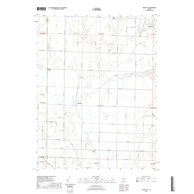
2019 Map of Saline City
USGS Topo · Published 2019About this map
Saline City and the surrounding river bottomlands define this portion of Clay County, where the Eel River and its numerous tributaries create a complex network of drainage and low-lying terrain. The landscape is marked by the presence of Hickory Island and a series of managed waterways like Lafferty Ditch and Conneley Ditch, illustrating decades of agricultural water management. The settlement of Old Hill sits near the river's edge, while historical continuity is preserved at several local burial grounds, including Maple Grove Cem, Zion Gummere Cem, and Staggs Cem. Transportation across the river is facilitated by landmarks like the Neal Mill Bridge, and the Turner Farms Airport serves the local rural aviation needs. This map captures the area's rural character and the enduring relationship between the community and the winding course of the Eel River.
Find a feature on this map
57 named features on this map. Tap any name to fly to it.
Don’t see what you’re looking for? This feature index may not catch every label — zoom into the map to look around manually.
Map Details
Editions of this 2019 Saline City Map
This is the sole edition of this map. No revisions or reprints were ever made.
Other maps of this area

1908 · Clay City
USGS Topo · 1:48,000

1910 · Clay City
USGS Topo · 1:62,500

1938 · Coal City
USGS Topo · 1:24,000

1940 · Lewis
USGS Topo · 1:24,000

1940 · Jasonville
USGS Topo · 1:24,000

1941 · Seelyville
USGS Topo · 1:24,000

1943 · Hymera
USGS Topo · 1:24,000

1948 · Coal City
USGS Topo · 1:24,000
1952 · Lewis
USGS Topo · 1:24,000

1952 · Seelyville
USGS Topo · 1:24,000