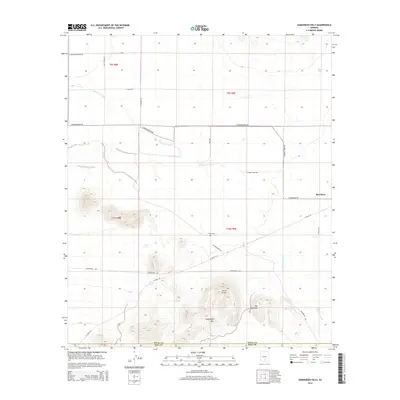
2014 Map of Samaniego Hills
USGS Topo · Published 2014About this map
Samaniego Hills and the prominent volcanic rises of Cerro Prieto and Pan Quemado dominate this Southern Arizona landscape near the border of Pinal and Pima counties. The desert floor is defined by the braided path of the Santa Cruz River and the artificial channel of the Greene Canal, which draw a stark line across the arid flats. Near the center of the quadrangle, the Sasco Cem remains as a quiet legacy of the former copper smelting town of Sasco, providing a critical anchor for local genealogists and historians. To the east, the settlement of Red Rock sits along the transportation corridor, while water features like Sasco Tank and Los Robles Wash illustrate the complex hydrology of the Sonoran basin. The map reveals a transition between rugged mountain peaks and the wide alluvial plains used for ranching and agriculture, marked by a network of rural routes such as E Sasco Rd and S La Osa Ranch Rd.
Find a feature on this map
28 named features on this map. Tap any name to fly to it.
Don’t see what you’re looking for? This feature index may not catch every label — zoom into the map to look around manually.
Map Details
Editions of this 2014 Samaniego Hills Map
This is the sole edition of this map. No revisions or reprints were ever made.
Other maps of this area

1934 · Tucson Mountains
USGS Topo · 1:125,000

1934 · Silver Bell
USGS Topo · 1:125,000

1934 · Newman Peak
USGS Topo · 1:125,000

1947 · Red Rock
USGS Topo · 1:62,500

1947 · Eloy
USGS Topo · 1:62,500

1948 · Eloy
USGS Topo · 1:62,500

1956 · Tucson
USGS Topo · 1:250,000

1958 · Tucson
USGS Topo · 1:250,000

1959 · Tucson
USGS Topo · 1:250,000

1959 · Vaca Hills
USGS Topo · 1:62,500