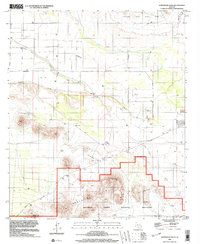
1996 Map of Samaniego Hills
USGS Topo · Published 2003About this map
Sasco (Site) serves as a primary historical anchor in this desert landscape, once a thriving smelter town serving nearby silver and copper mines. The map reveals the layout of the former settlement alongside the Sasco Cem and the Sasco Tank, providing clear evidence of the town's industrial footprint at the turn of the millennium. The path of the Old RR Grade cuts through the terrain, marking the transportation corridor that once linked this remote outpost to the wider rail network.
Find a feature on this map
19 named features on this map. Tap any name to fly to it.
Don’t see what you’re looking for? This feature index may not catch every label — zoom into the map to look around manually.
Map Details
Editions of this 1996 Samaniego Hills Map
This is the sole edition of this map. No revisions or reprints were ever made.
Other maps of this area

1934 · Tucson Mountains
USGS Topo · 1:125,000

1934 · Silver Bell
USGS Topo · 1:125,000

1934 · Newman Peak
USGS Topo · 1:125,000

1947 · Red Rock
USGS Topo · 1:62,500

1947 · Eloy
USGS Topo · 1:62,500

1948 · Eloy
USGS Topo · 1:62,500

1956 · Tucson
USGS Topo · 1:250,000

1958 · Tucson
USGS Topo · 1:250,000

1959 · Tucson
USGS Topo · 1:250,000

1959 · Vaca Hills
USGS Topo · 1:62,500