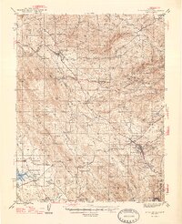
1947 Map of San Andreas
USGS Topo · Published 1947About this map
San Andreas and the Mother Lode mining belt dominate this post-war survey, revealing a landscape defined by deep-vein gold extraction and early California ranching. The map details an intensive industrial network surrounding Angels and Altaville, where numerous workings like the Gold Cliff Mine and Sultana Mine cluster along the ridge lines. The presence of the Pacific Southern RR and the Cement Plant at Kentucky House underscores the transition toward larger-scale industrial processing.
Find a feature on this map
81 named features on this map. Tap any name to fly to it.
Don’t see what you’re looking for? This feature index may not catch every label — zoom into the map to look around manually.
Map Details
Editions of this 1947 San Andreas Map
2 editions found

Other maps of this area

1889 · Jackson
USGS Topo · 1:125,000

1891 · Big Trees
USGS Topo · 1:125,000

1892 · Jackson
USGS Topo · 1:125,000

1893 · Sonora
USGS Topo · 1:125,000

1894 · Big Trees
USGS Topo · 1:125,000

1896 · Sonora
USGS Topo · 1:125,000

1897 · Jackson
USGS Topo · 1:125,000

1897 · Sonora
USGS Topo · 1:125,000

1897 · Big Trees
USGS Topo · 1:125,000

1898 · Sonora
USGS Topo · 1:125,000