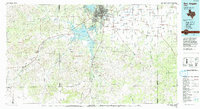
1986 Map of San Angelo
USGS Topo · Published 1993About this map
San Angelo serves as the hub of this West Texas landscape, where the confluence of the North Concho River and South Concho River meets the expansive waters of Lake Nasworthy and Twin Buttes Reservoir. The map illustrates the region's mid-1980s configuration, dominated by the sprawling operations of Goodfellow Air Force Base and the historic footprint of Fort Concho. Beyond the city, the terrain transitions into a patchwork of ranching and energy extraction, characterized by the Toenail Oil Field and the Neva West Oil and Gas Field. Rural life is centered around small outposts such as Knickerbocker, Sherwood, and Mertzon. Extensive drainage networks, including Lipan Creek and Spring Creek, reveal the hydrological patterns of the Edwards Plateau's edge, while landmarks like Lopez Peaks provide topographic variation in a region defined by its wide draws and strategic water management.
Find a feature on this map
61 named features on this map. Tap any name to fly to it.
Don’t see what you’re looking for? This feature index may not catch every label — zoom into the map to look around manually.
Map Details
Editions of this 1986 San Angelo Map
2 editions found
Other maps of this area

1891 · Hayrick
USGS Topo · 1:125,000

1892 · San Angelo
USGS Topo · 1:125,000

1892 · Eden
USGS Topo · 1:125,000

1892 · Ballinger
USGS Topo · 1:125,000

1893 · Fort McKavett
USGS Topo · 1:125,000

1894 · Hayrick
USGS Topo · 1:125,000

1895 · Sherwood
USGS Topo · 1:125,000

1896 · Eden
USGS Topo · 1:125,000

1920 · Barnhart
USGS Topo · 1:62,500

1921 · Lowake
USGS Topo · 1:31,680