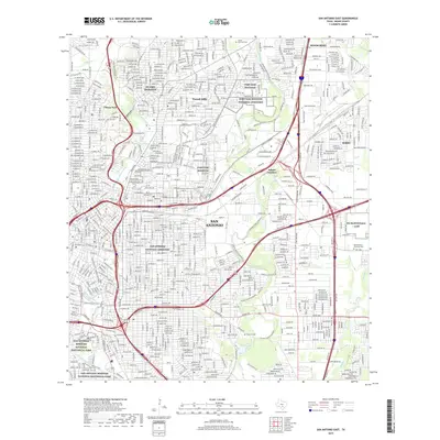
2019 Map of San Antonio East
USGS Topo · Published 2019About this map
The San Antonio River and Salado Creek corridors define this urban landscape, where the massive grounds of Fort Sam Houston and the Fort Sam Houston National Cemetery occupy a significant portion of the northeast quadrant. This modern survey illustrates the dense residential growth surrounding established enclaves like Alamo Heights, Terrell Hills, and Olmos Park. To the south, the preservation of early Texas history is evident in the San Antonio Missions National Historical Park, a contrast to the extensive freeway networks of Loop 410 and I-35 that facilitate the city's modern movement. Significant local landmarks such as Olmos Reservoir and the San Antonio Springs mark the area's hydrology, while the Salado Creek Greenway provides a continuous recreational corridor through the industrialized eastern sections near Kirby.
Find a feature on this map
47 named features on this map. Tap any name to fly to it.
Don’t see what you’re looking for? This feature index may not catch every label — zoom into the map to look around manually.
Map Details
Editions of this 2019 San Antonio East Map
This is the sole edition of this map. No revisions or reprints were ever made.
Other maps of this area

1953 · Schertz
USGS Topo · 1:24,000

1953 · San Antonio West
USGS Topo · 1:24,000

1953 · San Antonio East
USGS Topo · 1:24,000

1953 · Terrell Wells
USGS Topo · 1:24,000

1953 · Longhorn
USGS Topo · 1:24,000

1953 · Elmendorf
USGS Topo · 1:24,000

1953 · Southton
USGS Topo · 1:24,000

1953 · Castle Hills
USGS Topo · 1:24,000

1953 · Martinez
USGS Topo · 1:24,000

1954 · San Antonio
USGS Topo · 1:250,000