
1912 Map of San Ardo
USGS Topo · Published 1912About this map
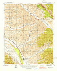
The Salinas River corridor defines this 1912 survey of southern Monterey County, revealing the early infrastructure of the San Ardo region. The Coast Line railroad runs parallel to the river, serving as the primary artery for transportation and trade during a period when agriculture was firmly established in the valley. A significant landmark for local historians and genealogists is the Paris School, located west of the river, which served the rural families of the surrounding ranch lands.
Find a feature on this map
8 named features on this map. Tap any name to fly to it.
Don’t see what you’re looking for? This feature index may not catch every label — zoom into the map to look around manually.
Map Details
Editions of this 1912 San Ardo Map
This is the sole edition of this map. No revisions or reprints were ever made.
Other maps of this area

1915 · Priest Valley
USGS Topo · 1:125,000

1919 · King City
USGS Topo · 1:62,500

1919 · Bryson
USGS Topo · 1:62,500

1919 · Bradley
USGS Topo · 1:62,500

1939 · King City
USGS Topo · 1:62,500
1941 · San Ardo
USGS Topo · 1:62,500
1941 · Bradley
USGS Topo · 1:62,500

1941 · Bryson
USGS Topo · 1:62,500

1942 · Bryson
USGS Topo · 1:62,500
1943 · San Ardo
USGS Topo · 1:62,500