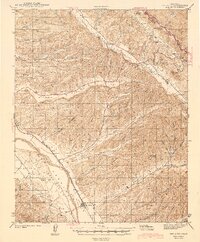
1943 Map of San Ardo
USGS Topo · Published 1943About this map
The Salinas River corridor defines the western edge of this 1940s landscape, serving as the primary artery for both the Southern Pacific railroad and the historic Camino Real. The settlement of San Ardo sits at the base of a complex network of canyons and ridges, where the terrain rises sharply into Mustang Ridge and the Peachtree Valley. This survey captures the rural character of southeastern Monterey County just before mid-century, detailing the remote Lewis Creek Sch and numerous family-named landmarks like Cleveland Rock and Nigger Hill. The map reveals a highly dissected landscape where seasonal drainages such as Pancho Rico and Mooney Creek have carved distinct valleys, including Long Valley and Rico Valley, creating a rugged hinterland characterized by isolated springs like Brinnan Springs and Iron Springs.
Find a feature on this map
55 named features on this map. Tap any name to fly to it.
Don’t see what you’re looking for? This feature index may not catch every label — zoom into the map to look around manually.
Map Details
Editions of this 1943 San Ardo Map
2 editions found

Other maps of this area

1912 · San Ardo
USGS Topo · 1:31,680

1915 · Priest Valley
USGS Topo · 1:125,000

1919 · San Miguel
USGS Topo · 1:62,500

1919 · King City
USGS Topo · 1:62,500

1919 · Bryson
USGS Topo · 1:62,500

1919 · Bradley
USGS Topo · 1:62,500

1921 · Metz
USGS Topo · 1:62,500

1939 · King City
USGS Topo · 1:62,500

1940 · Metz
USGS Topo · 1:62,500

1941 · Priest Valley
USGS Topo · 1:62,500