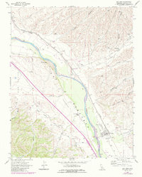
1967 Map of San Ardo
USGS Topo · Published 1984About this map
The Salinas River valley dominates this portion of Monterey County, serving as the primary corridor for agriculture and transportation. The settlement of San Ardo sits alongside the Southern Pacific tracks, supporting a rural economy characterized by Grain Elevators Storage Bins and a Radio Facility. The landscape transitions from the river bottom into several distinct valleys, including Pine Valley, Paris Valley, and Pancho Rico Valley, each flanked by a network of drainage systems like Coyote Canyon and Pancho Rico Creek. The infrastructure of the era is evident through features like the Airway Beacon and a Substation, while local transit is anchored by Dudley Road and Sargents Road. For genealogists and local historians, the inclusion of the Cem near the town center and family-named landmarks like Jim Lawson Gulch and Garrissere Canyon provide specific points for tracing regional lineage.
Find a feature on this map
27 named features on this map. Tap any name to fly to it.
Don’t see what you’re looking for? This feature index may not catch every label — zoom into the map to look around manually.
Map Details
Editions of this 1967 San Ardo Map
4 editions found

Other maps of this area

1912 · San Ardo
USGS Topo · 1:31,680

1915 · Priest Valley
USGS Topo · 1:125,000

1919 · King City
USGS Topo · 1:62,500

1919 · Bryson
USGS Topo · 1:62,500

1919 · Bradley
USGS Topo · 1:62,500

1939 · King City
USGS Topo · 1:62,500

1941 · San Ardo
USGS Topo · 1:62,500

1941 · Bradley
USGS Topo · 1:62,500

1941 · Bryson
USGS Topo · 1:62,500

1942 · Bryson
USGS Topo · 1:62,500