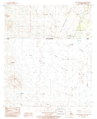
1985 Map of San Bernardino Ranch
USGS Topo · Published 1986About this map
The San Bernardino Ranch stands as a central landmark in this borderlands survey, where the San Bernardino Valley straddles the international boundary between the United States and Mexico. This desert landscape is defined by its vital water sources, including the Black Draw and Silver Creek, which supported cattle ranching and early habitation in Cochise County and across the line into Sonora. Evidence of the region's human geography is noted through the San Bernardino settlement, a small Cem, and scattered Prospects in the western hills.
Find a feature on this map
27 named features on this map. Tap any name to fly to it.
Don’t see what you’re looking for? This feature index may not catch every label — zoom into the map to look around manually.
Map Details
Editions of this 1985 San Bernardino Ranch Map
This is the sole edition of this map. No revisions or reprints were ever made.
Other maps of this area

1919 · Perilla
USGS Topo · 1:125,000

1922 · McDonald
USGS Topo · 1:62,500

1940 · College Peaks
USGS Topo · 1:62,500

1955 · Douglas
USGS Topo · 1:250,000

1958 · Guadalupe Canyon
USGS Topo · 1:62,500
1958 · College Peaks
USGS Topo · 1:62,500

1959 · Douglas
USGS Topo · 1:250,000

1961 · Douglas
USGS Topo · 1:250,000

1964 · Douglas
USGS Topo · 1:250,000
1985 · Lazy J Ranch
USGS Topo · 1:24,000