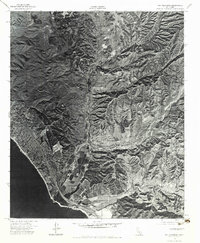
1974 Map of San Clemente
USGS Topo · Published 1975About this map
Camp Pendleton Marine Corps Base dominates the landscape in this mid-1970s orthophotograph, where the developing Southern California coast meets the rugged training grounds of the military. The aerial imagery captures the sharp contrast between the dense residential expansion of San Clemente and the largely undeveloped terrain of the adjacent base. Drainage patterns are clearly visible through Gabino Canyon and Cristianitos Canyon, revealing the natural erosion of the coastal hills before they meet the Pacific Ocean. This survey provides a unique visual record of land use at the Orange County border during a decade of rapid suburban growth, showing the intricate network of canyons that defined the area's geography before further modern development.
Find a feature on this map
4 named features on this map. Tap any name to fly to it.
Don’t see what you’re looking for? This feature index may not catch every label — zoom into the map to look around manually.
Map Details
Editions of this 1974 San Clemente Map
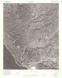
2 editions found
Other maps of this area

1901 · Southern California Sheet No. 1
USGS Topo · 1:250,000

1901 · Elsinore
USGS Topo · 1:125,000

1901 · San Luis Rey
USGS Topo · 1:125,000

1902 · Capistrano
USGS Topo · 1:125,000

1902 · Corona
USGS Topo · 1:125,000

1904 · Southern California Sheet No. 2
USGS Topo · 1:250,000

1904 · Southern California Sheet No. 1
USGS Topo · 1:250,000

1906 · Capistrano
USGS Topo · 1:125,000

1941 · Margarita Peak
USGS Topo · 1:62,500

1942 · Lake Elsinore
USGS Topo · 1:62,500
Featured Places
- San Clemente, CA
- San Juan Capistrano, CA
- Marine Corps Base Camp Pendleton, CA
- San Onofre, Marine Corps Base Camp Pendleton
- San Diego County, CA