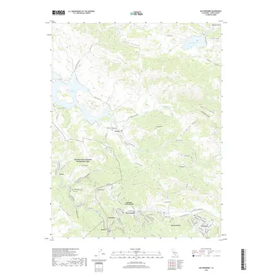
2018 Map of San Geronimo
USGS Topo · Published 2018About this map
Nicasio stands at the heart of this Marin County landscape, where the confluence of Halleck Cr and Nicasio Cr feeds into the expansive Nicasio Reservoir. The settlement pattern follows the valley floor, with small communities like San Geronimo, Woodacre, and Lagunitas-Forest Knolls clustered along Sir Francis Drake Blvd. This corridor provides a stark contrast to the surrounding ridges, such as Big Rock Ridge and Bolinas Ridge, which hem in the narrow canyons. Historical markers of the area's development are preserved in labels for Shafter Bridge and the Taylor Cem near Deadmans Gulch. Much of the western terrain is dedicated to the Golden Gate National Recreation Area, protecting the drainages of Devils Gulch Cr and the heights of Barnabe Mtn. The map clearly illustrates the transition from the open waters of Stafford Lake in the northeast to the dense trail networks of the coastal range.
Find a feature on this map
91 named features on this map. Tap any name to fly to it.
Don’t see what you’re looking for? This feature index may not catch every label — zoom into the map to look around manually.
Map Details
Editions of this 2018 San Geronimo Map
This is the sole edition of this map. No revisions or reprints were ever made.
Other maps of this area

1897 · Tamalpais
USGS Topo · 1:62,500

1914 · Petaluma
USGS Topo · 1:62,500

1916 · Point Reyes
USGS Topo · 1:48,000

1918 · Point Reyes
USGS Topo · 1:62,500

1941 · Tamalpais
USGS Topo · 1:62,500

1942 · Petaluma
USGS Topo · 1:62,500

1947 · Santa Rosa
USGS Topo · 1:250,000

1947 · San Francisco
USGS Topo · 1:250,000

1948 · San Francisco
USGS Topo · 1:250,000

1949 · Santa Rosa
USGS Topo · 1:250,000