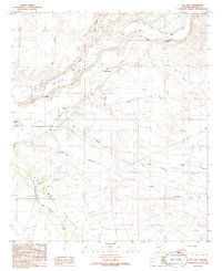
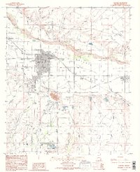
1985 Map of San Jose
USGS Topo · Published 1986About this map
The Gila River and its accompanying Gila Valley agricultural infrastructure define this Arizona landscape in the mid-1980s. A complex system of irrigation, featuring the Tidwell Canal and Brown Canal, supports a string of rural settlements including San Jose, Sanchez, and Buena Vista. These communities are concentrated along the northern edge of the valley, where the terrain shifts toward Earven Flat. The map highlights the intersection of water and transport, with the San Simon River flowing through the San Simon Valley to join the Gila near the town of Solomon. Industrial markers such as the Grain Bins and a Prospect underscore the area's dual reliance on ranching and mineral exploration. The presence of the Aqueduct and various siphons illustrates the sophisticated engineering required to manage water in Graham County's arid environment.
Find a feature on this map
29 named features on this map. Tap any name to fly to it.
Don’t see what you’re looking for? This feature index may not catch every label — zoom into the map to look around manually.
Map Details
Editions of this 1985 San Jose Map
This is the sole edition of this map. No revisions or reprints were ever made.
Other maps of this area

1954 · Silver City
USGS Topo · 1:250,000

1958 · Silver City
USGS Topo · 1:250,000

1960 · Guthrie
USGS Topo · 1:62,500

1960 · Safford
USGS Topo · 1:62,500

1962 · Silver City
USGS Topo · 1:250,000
1966 · Artesia NE
USGS Topo · 1:24,000

1966 · Artesia
USGS Topo · 1:24,000
1966 · Dry Mountain
USGS Topo · 1:24,000
1985 · Gila Box
USGS Topo · 1:24,000
1985 · Safford
USGS Topo · 1:24,000