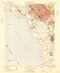
1948 Map of San Leandro
USGS Topo · Published 1948About this map
San Francisco Bay shorelines and the industrializing San Leandro Valley define this late 1940s landscape. The map captures the East Bay during a period of rapid post-war residential expansion, evidenced by the development of San Lorenzo Village and the dense street grids of San Leandro and Oakland. Along the coast, a specialized economy is visible through the Salt Evaporating Ponds and historical maritime points like Mulford Landing, Roberts Landing, and Hayward Landing.
Find a feature on this map
56 named features on this map. Tap any name to fly to it.
Don’t see what you’re looking for? This feature index may not catch every label — zoom into the map to look around manually.
Map Details
Editions of this 1948 San Leandro Map
This is the sole edition of this map. No revisions or reprints were ever made.
Other maps of this area

1892 · San Mateo
USGS Topo · 1:62,500

1895 · San Francisco
USGS Topo · 1:62,500

1896 · San Mateo
USGS Topo · 1:62,500

1897 · Concord
USGS Topo · 1:62,500

1899 · San Francisco
USGS Topo · 1:62,500

1899 · Haywards
USGS Topo · 1:62,500

1899 · San Mateo
USGS Topo · 1:62,500

1915 · San Mateo
USGS Topo · 1:62,500

1915 · Haywards
USGS Topo · 1:62,500

1915 · Concord
USGS Topo · 1:62,500