1959 Map of San Leandro
USGS Topo · Published 1980About this map
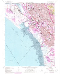
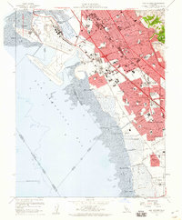
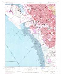
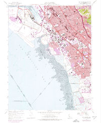
The Metropolitan Oakland International Airport dominates the northwestern shoreline, showcasing the mid-century expansion of aviation infrastructure alongside the Airport Channel. This era of the East Bay is defined by rapid suburbanization and the heavy infrastructure of the Nimitz Freeway, which carves through established neighborhoods. The map illustrates a dense network of local education, featuring numerous campuses such as San Leandro High Sch, Arroyo High Sch, and Louis Bertrand School. Industrial and transport history is preserved through the corridors of the Southern Pacific and Western Pacific railroads, which once serviced the various landings along the San Francisco Bay mudflats, including Roberts Landing and Hayward Landing. The inclusion of the Oakland-Alameda Co Coliseum Complex in purple revision marks the shift toward large-scale regional landmarks during the late twentieth century.
Find a feature on this map
63 named features on this map. Tap any name to fly to it.
Don’t see what you’re looking for? This feature index may not catch every label — zoom into the map to look around manually.
Map Details
Editions of this 1959 San Leandro Map
4 editions found
Other maps of this area

1892 · San Mateo
USGS Topo · 1:62,500

1895 · San Francisco
USGS Topo · 1:62,500

1896 · San Mateo
USGS Topo · 1:62,500

1897 · Concord
USGS Topo · 1:62,500

1899 · San Francisco
USGS Topo · 1:62,500

1899 · Haywards
USGS Topo · 1:62,500

1899 · San Mateo
USGS Topo · 1:62,500

1915 · San Mateo
USGS Topo · 1:62,500

1915 · Haywards
USGS Topo · 1:62,500

1915 · Concord
USGS Topo · 1:62,500