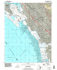
1993 Map of San Leandro
USGS Topo · Published 1997About this map
The eastern shoreline of San Francisco Bay is defined by an intricate network of industrial, residential, and recreational development in this detailed mid-1990s study. The vast grounds of the Metropolitan Oakland International Airport and the nearby Oakland-Alameda Co Coliseum Complex dominate the northern portion of the quadrangle, illustrating the massive scale of infrastructure supporting the Oakland and San Leandro corridor. Along the water, a series of historical landing sites such as Mulford Landing, Roberts Landing, and Johnson Landing speak to the area's maritime heritage before the expansion of modern marinas like the San Leandro Marina. Inland, the map reveals a dense suburban fabric interspersed with numerous community spaces like Washington Manor Park and Victoria Park. Large swaths of Salt Evaporators near Hayward provide a stark visual contrast to the grid of the Nimitz Freeway, marking the transition from the built environment to the tidal flats of the bay.
Find a feature on this map
53 named features on this map. Tap any name to fly to it.
Don’t see what you’re looking for? This feature index may not catch every label — zoom into the map to look around manually.
Map Details
Editions of this 1993 San Leandro Map
This is the sole edition of this map. No revisions or reprints were ever made.
Other maps of this area

1892 · San Mateo
USGS Topo · 1:62,500

1895 · San Francisco
USGS Topo · 1:62,500

1896 · San Mateo
USGS Topo · 1:62,500

1897 · Concord
USGS Topo · 1:62,500

1899 · San Francisco
USGS Topo · 1:62,500

1899 · Haywards
USGS Topo · 1:62,500

1899 · San Mateo
USGS Topo · 1:62,500

1915 · San Mateo
USGS Topo · 1:62,500

1915 · Haywards
USGS Topo · 1:62,500

1915 · Concord
USGS Topo · 1:62,500