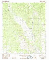
1985 Map of San Lorenzo
USGS Topo · Published 1985About this map
The Mimbres River valley serves as the central artery for this mid-1980s Grant County landscape, where the agricultural settlements of San Lorenzo and Mimbres sit flanked by the foothills of the Gila National Forest. This region shows a distinct pattern of valley floor habitation, with numerous small irrigation ditches and siphons paralleling the river to support local ranching and farming. North of San Lorenzo, the terrain breaks into a series of deeply etched drainages including Noonday Canyon and Ancheta Canyon.
Find a feature on this map
20 named features on this map. Tap any name to fly to it.
Don’t see what you’re looking for? This feature index may not catch every label — zoom into the map to look around manually.
Map Details
Editions of this 1985 San Lorenzo Map
This is the sole edition of this map. No revisions or reprints were ever made.
Other maps of this area
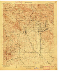
1909 · Silver City
USGS Topo · 1:125,000

1937 · Santa Rita
USGS Topo · 1:24,000
1947 · Allie Canyon
USGS Topo · 1:24,000

1948 · Santa Rita
USGS Topo · 1:24,000

1948 · Allie Canyon
USGS Topo · 1:24,000

1948 · Hurley East
USGS Topo · 1:24,000

1949 · Hurley East
USGS Topo · 1:24,000
1951 · Santa Rita
USGS Topo · 1:24,000

1954 · Silver City
USGS Topo · 1:250,000

1955 · Las Cruces
USGS Topo · 1:250,000