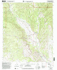
1999 Map of San Lorenzo
USGS Topo · Published 2002About this map
The Mimbres River valley forms the central corridor of this late-twentieth-century study, where agricultural and community life concentrate along the river's path. In San Lorenzo, the landscape includes community infrastructure like an Airstrip, an Athletic Field, and a Substation, while further downstream, the settlement of San Juan utilizes a Siphon and Ditch system for irrigation.
Find a feature on this map
34 named features on this map. Tap any name to fly to it.
Don’t see what you’re looking for? This feature index may not catch every label — zoom into the map to look around manually.
Map Details
Editions of this 1999 San Lorenzo Map
This is the sole edition of this map. No revisions or reprints were ever made.
Other maps of this area
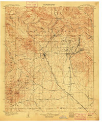
1909 · Silver City
USGS Topo · 1:125,000

1937 · Santa Rita
USGS Topo · 1:24,000
1947 · Allie Canyon
USGS Topo · 1:24,000

1948 · Santa Rita
USGS Topo · 1:24,000

1948 · Allie Canyon
USGS Topo · 1:24,000

1948 · Hurley East
USGS Topo · 1:24,000

1949 · Hurley East
USGS Topo · 1:24,000
1951 · Santa Rita
USGS Topo · 1:24,000

1954 · Silver City
USGS Topo · 1:250,000

1955 · Las Cruces
USGS Topo · 1:250,000