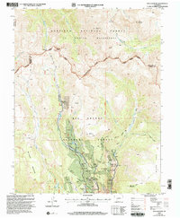
2001 Map of San Luis Peak
USGS Topo · Published 2005About this map
Mining operations and high mountain passes define this high-altitude landscape of the San Juan Mountains at the start of the 21st century. The legacy of extraction is visible along West Willow Creek, where the Equity Mine Mine Dump and the Amethyst Mine sit near former town locations like Bachelor (Site) and Weaver (Site). These settlements, once active centers of industry, are shown alongside the intricate network of the Commodore Mine and Solomon Mine.
Find a feature on this map
37 named features on this map. Tap any name to fly to it.
Don’t see what you’re looking for? This feature index may not catch every label — zoom into the map to look around manually.
Map Details
Editions of this 2001 San Luis Peak Map
This is the sole edition of this map. No revisions or reprints were ever made.
Other maps of this area

1905 · San Cristobal
USGS Topo · 1:125,000

1907 · San Cristobal
USGS Topo · 1:125,000

1908 · Uncompahgre
USGS Topo · 1:125,000

1911 · Uncompahgre
USGS Topo · 1:125,000

1914 · Creede
USGS Topo · 1:125,000

1916 · Creede
USGS Topo · 1:125,000

1945 · Durango
USGS Topo · 1:250,000

1953 · Durango
USGS Topo · 1:250,000

1954 · Durango
USGS Topo · 1:250,000

1956 · Montrose
USGS Topo · 1:250,000